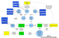
COSEE-OS concept maps are designed to help teachers and their students understand the connections and relationships between climate & oceanography. These maps are created through discussion and collaboration and are ideal instruments in revealing their authors' understanding of a topic. For scientists, concept mapping helps them share their understanding of connections in the earth system. For educators, concept maps can be powerful tools for exposing and clarifying topics in the classroom.
Scientist's concept maps guided the design of the "Ocean-Climate Interactive" that allows web visitors to "journey" through the Earth-Sun System, down to Earth's surface, and finally explore the ocean at the smallest scales. Visit the Ocean-Climate Interactive that resulted from the scientists' map at right.