|
|
July Sea Ice Second Lowest - Record Low Unlikely for 2010
08/25/2010
| Marilyn Sigman, Alaska SeaGrant/MAP
Tags: Climate Change, Changing Arctic Sea Ice, Arctic Ocean
|
The National Sea and Ice Data Center (NSIDC) reported that a surge in late winter ice growth resulted in a delay of one week in the onset of ice melt in the Beaufort, Chukchi, East Siberian, and Bering seas, compared to the 1979-2000 average. In contrast, melt started one to two weeks earlier than the average in the eastern Arctic and at about the average time in central Arctic.
By the end of July, however, air temperatures that were higher than normal during spring and summer resulted in an Arctic sea ice extent that was the second lowest in the satellite record, after 2007. After a slowdown in the rate of ice loss, the old, thick ice that moved into the southern Beaufort Sea last winter was beginning to melt out. Average ice extent for July was 8.39 million square kilometers (3.24 million square miles), 1.71 million square kilometers (660,000 square miles) below the 1979 to 2000 mean, but 260,000 square kilometers (100,000 square miles) above the average for July 2007, the lowest July in the thirty-two-year satellite record. The linear rate of decline of July ice extent over the period 1979 to 2010 is now 6.4% per decade.
Stormy, cloudy, and relatively cool weather persisted throughout July, which helped slow the rate of ice loss. The daily rate of decline for July was close to the 1979 to 2000 average. This led the NSIDC to predict that the cool, stormy weather July would make it less likely that the upcoming 2010 sea ice minimum would set a new record unless an unusual set of conditions occurred in August. The Study of Environmental Arctic Change (SEARCH) released its July outlook for September based on a synthesis of 17 individual pan-Arctic individual estimates using a wide range of methods. The outlook suggested a 29% chance of reaching a new September sea ice minimum in 2010 and only an 18% chance of an extent greater than the 2009 minimum. More than half of the contributions to the outlook suggested a September minimum that would remain below 5 million square kilometers, representing a continued trend of declining sea ice.
By August 17, the end of summer was approaching in the Arctic; temperatures were dropping and melt was ending in the high latitudes. In the lower latitudes of the Arctic Ocean, however, sea ice extent was continuing to decline. Sea ice had melted out extensively in the northern route of the Northwest Passage, but the passage was not completely open. Arctic ice extent on that date was 5.95 million square kilometers (2.30 million square miles),1.68 million square kilometers (649,000 square miles) below the 1979-2000 average.
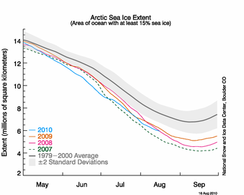 This graph shows daily Arctic sea ice extent as of August 16, 2010. The solid light blue line indicates 2010; dashed green shows 2007; solid pink shows 2008; solid orange shows 2009; and solid gray indicates average extent from 1979 to 2000. The gray area around the average line shows the two standard deviation range of the data. Sea Ice Index data. (Credit: National Snow and Ice Data Center) |
Old Ice is Melting
This past winter's negative phase of the Arctic Oscillation transported old ice (four, five, and more years old) from an area north of the Canadian Archipelago. The ice was flushed southwards and westward into the Beaufort and Chukchi seas. Ice age data show that back in the 1970s and 1980s, old ice drifting into the Beaufort Sea would generally survive the summer melt season. However, the old, thick ice that moved into this region is now beginning to melt out, which could further deplete the Arctic’s remaining store of old, thick ice. The loss of thick ice has been implicated as a major cause of the very low September sea ice minima observed in recent years.
More information and analysis is available in other NSIDC weekly reports for August, 2010 archived on the NSIDC website (link above).
|

